Y-HARP (Yangliuqing Historical Area Regeneration Plan)
| 완공년도 | 2020 |
| 위치 | 중국 천진시 |
| 대지면적 | 1,877,000㎡ |
| Landscape | 서안 |
| 완공년도 | 2020 |
| 위치 | 중국 천진시 |
| 대지면적 | 1,877,000㎡ |
| Landscape | 서안 |
An Ancient Future: Yangliuqing Historical Area Regeneration Plan
The Yangliuqing Grand Canal National Cultural Park is an urban-scale project, for which the government of Xiqing District, Tianjin commissioned CBC to hold a global invitational competition in May 2020. IROJE architects and planners formed a team together with Seo-ahn Total Landscape and Urban Transformer for a proposal that won the first prize.
Yangliuqing is an area located in the west end of Tianjin. The area was developed in the Sui Dynasty in the 7th century and was completed during the Ming Dynasty. Along the Grand Canal from Hangzhou to Beijing, covering a total length of 2,700 kilometres, Yangliuqing is located at an intersection between the South Canal and the North Canal. Yangliuqing is directly translated to ’green willows’, attributing to the willows growing in low wetlands.
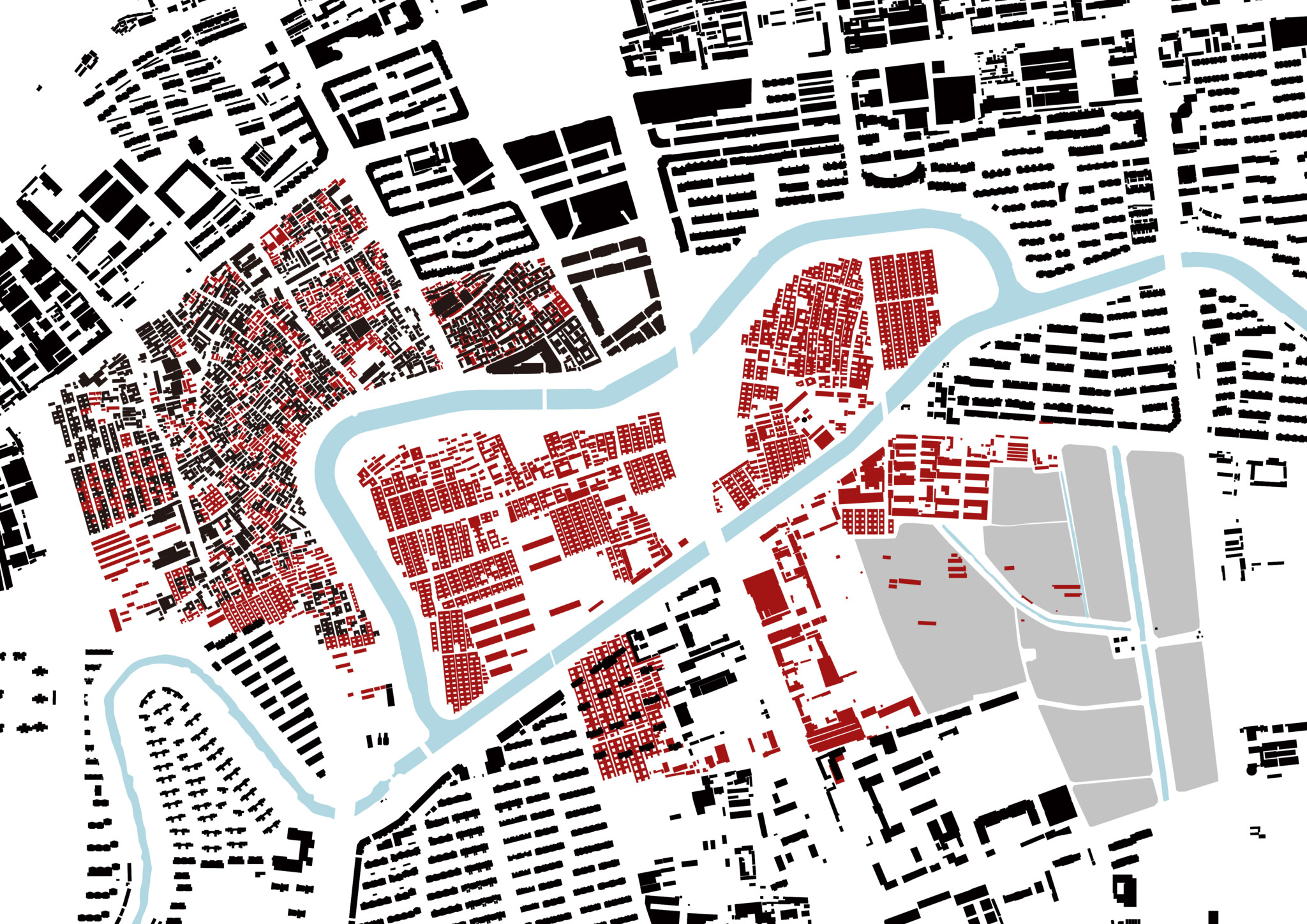
The project consists of three parts: Yuanbao Island, which became an island as a result of the construction of a straight canal connecting the two southern points of the meandering canal, which was the center of logistics due to its many curves, the historic reserve where many traditional houses are still concentrated on the northern side of Yuanbao Island, and the cultural town on its south. The three covers an area of 88ha, 38ha and 62ha respectively, totaling 188ha.
Currently there is only one ancient pavilion in Yuanbao Island – the humble Wenchang Pavilion, but this used to be an area with flourishing cultural facilities such as academies along with dense residential buildings, making it a prosperous place. Prior to an excavation of the canal on the south side of Yuanbao Island, there were mostly wetlands and ponds here, providing the locals with a memory of an integrated landscape of nature and architecture. The historic reserve on the north maintains a solid urban structure with traditional buildings and old streets, but it seemed to be struggling with the weight of history and there was a recognition that a new vitality was in need. The cultural town on the south also used to be agricultural land, requiring some development for utility.
Having lived through the same era but developed in different ways thus engraved with different textures, the three areas required separate solutions that will bring about new life. Therefore, our team proposed a different name for the project, Yangliuqing Historical Area Regeneration Plan (Y-HARP), to contain and highlight the characteristics of the design, instead of the original name (Yangliuqing Grand Canal National Cultural Park).
For regeneration of lands with an ancient history, we based our design on three established strategies according to the attributes of each area. Although the old villages of Yuanbao Island no longer exists and seems to be in a tabula rasa state, there were memories of vanished buildings and streets. It was more essential and authentic to work through a re-fabrication of the old fabric than to construct groundless new building. We were aspiring to realise this through the architectural language of ‘landscript’ by Seung H-Sang.
The historic reserve on the north needed some vitality. Proposed solution was a re-habilitation, where small facilities are installed or injected to the town for regeneration of traditional villages. Just like an acupunctural treatment for the veins of the town as opposed to a surgical operation, we took the approach to bring in small galleries, micro performance halls, small parks and other facilities to be placed for revivification. This is so called the ‘Urban Acupuncture’.
The cultural center on the south side of Yuanbao Island is a newly developed site. It aims to achieve a ‘Culturescape,’ a plan for a coordinated landscape, rather than an outstanding central facility. It is a concept of regeneration through an overall re-structuration of centralized large-scale cultural facilities such as opera theatres and art galleries.
Landscript, Urban Acupuncture, and Culturescape are the key words and vocabulary of the concept which shall be applied to every scale in order to complete the masterplan. Yuanbao Island is the focus of the project in particular, and the area was first target to be achieved. After the competition, the government of Xiqing District wanted to develop the Yuanbao Island first, therefore the masterplan phase 2 was progressed for Yuanbao Island, and the result was reported to the government in July 2020.
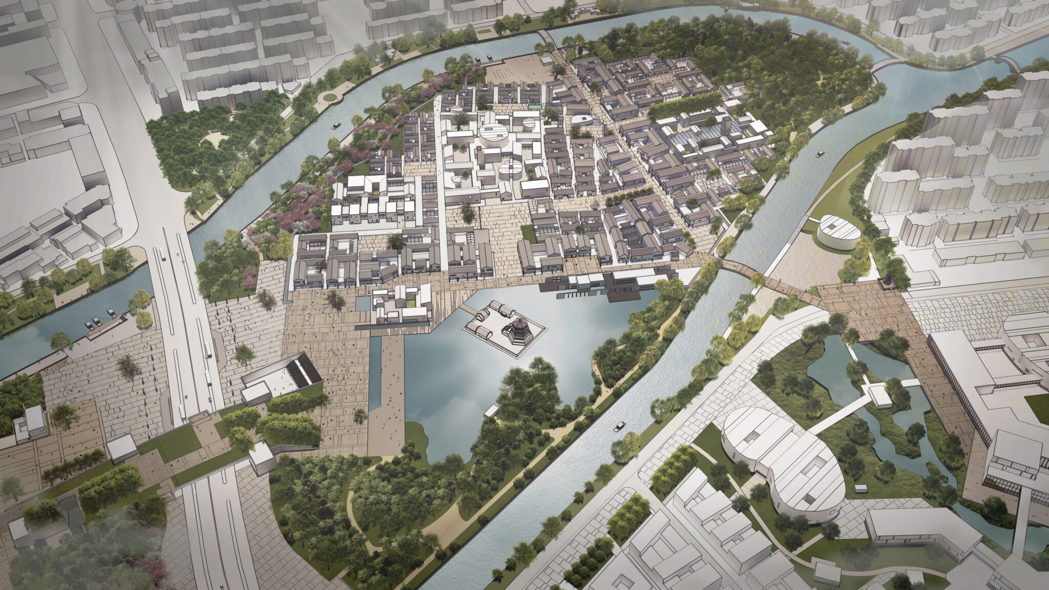
The key to the planning of Yuanbao Island is to restore the original landscape and spatial structure. Through in-depth analysis of the maps and documents of the past, we tried to explore the landscript and reconstruct the spatial structure of the past, hence reproduced the wetlands and ponds, and form streets and areas with a pleasant scale.
Traversed by Liukou Road, Yuanbao Island is divided into the west side and the east. The west side was given to accommodate the international garden expo in the future, hence most of which are reserved for flower garden plots and they are arranged according to the old paths of the village in. In addition to the garden expo and its supporting facilities, the West part is proposed with open-air theater and indoor concert hall along the canal. The indoor concert hall is including greenhouse and improves the identity.
The east side features the traditional culture in Yangliuqing. There are the New Year Picture Museum and other cultural facilities. These single buildings are not large-scale complex, but a combination of multiple small-scale ones suitable for the village-scale context, which their spatial structure is also based on the landscript.
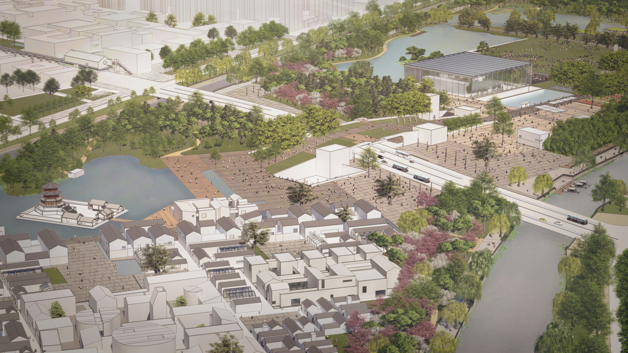
Yuanbao Island is mainly a pedestrian area, so on Liukou road with heavy traffic flow, a park is planned so as to connect the east and west side. By reshaping the topography, Wenchang Pavilion will float on the water, and Chongwen Academy will be located by the waterfront to create a distinctive village outline, together with the hilly park.
Yuanbao Island has three accessing points for vehicles. The vehicle accessing via bridges on the west of the west side and on the southeast side of the east side are directly connected to the underground. The garage runs through the east and west side and leads to various areas on the ground. Due to the current situation of Liukou Road with heavy traffic flow, emergency entrance and exit of the parking lot are placed according to the position of the entrance/exit of the subway to be developed in the later stage.
Landscape is very important in this project. Since the end of the 20th century, construction on Yuanbao Island has led to the destruction of the original topography. The proposed plan for Yuanbao Island should restore the topography and the inherent natural environment. Therefore, we will restore the wetlands and ponds, and use the excavated earth to build hills and ecological forests on the east and west sides. In result, ten feature landscapes have been proposed, turning into an ancient future.
Similar issues have happened in many different places, and will happen in the future. I hope that the planning of this project will serve as a model for reviewing these process of urbanism. Lands support the lives of all of us, and all cities and buildings are built on lands. Lands are not only the foundation of our life, but a long narrative history passed on to future generations.
오래된 미래– 양류칭 역사지구재생계획
어반스케일의 양류칭국가문화공원은 2020년 5월 중국 텐진시 시칭구정부에서 CBC에 의뢰하여 이뤄진 국제 지명설계경기로 이로재를 주축으로 조직된 서안조경, 어반트랜스포머의 연합팀이 제출한 안이 당선되었다.
텐진시의 서쪽 끝에 위치한 양류칭은, 7세기 수나라시대부터 건설하기 시작하여 명나라시대에 완성된, 항주에서 북경까지의 2,700km의 대운하 중에서 남운하에서 북운하로 바뀌는 지점에 있는 곳이다. 이곳은 원래 저습지가 발달한 탓에 버드나무가 많아 양류칭으로 불리었다.
설계의 범위는 크게 세 부분으로 나뉜다. 굴곡이 많아 물류의 중심이었던 이곳 사행천의 남쪽 두 지점을 직선으로 잇는 직행하천을 건설한 결과로 섬처럼 된 원보도와 원보도의 북측에 여전히 많은 전통가옥이 밀집한 역사명진보호구, 그리고 문화중심구로 명명된 원보도의 남쪽 지역, 이 세 지역으로 각각 88ha, 38ha, 62ha 합계 188ha 크기의 면적이다.
원보도는 현재 문창각이라는 오래된 정자 하나만 초라하게 남아 있지만 과거 이곳은 서원 등 많은 문화시설이 밀집한 거주시설과 함께 번창했던 곳이며 직행하천을 개설하기 전에는 연못과 습지가 즐비하여 자연과 건축이 어우러진 아름다운 풍경의 기억이 있는 곳이다. 북측의 역사명진보호구에는 오래된 전통건축이 오래된 가로와 함께 단단한 조직을 유지하고 있으나 역사의 무게를 힘겨워하는 듯 보여 새로운 활력이 필요한 것으로 판단되었으며, 원보도 남측의 문화중심구는 원래 농경지로 쓰였던 곳이라 이제 새로운 개발을 기대하고 있었다.
같은 시대를 지나면서도 서로 다른 무늬를 새겨온 이 세 지역은 서로 다른 해법이 필요하며 그로 인해 새로운 삶을 시작하여야 했다. 그래서 우리 팀은 주어진 ‘양류칭 국가문화대공원’이라는 제목 대신 ‘양류칭 역사지구재생계획(Yangliuqing Historical Area Regeneration Plan; Y-HARP)이라는 이름을 제시하며 설계의 성격을 요약했다.
오래된 땅을 재생(Regeneration)시키기 위하여 각 지역의 특성에 맞추어 세가지 전략을 세웠다. 오래된 마을의 형체를 모조리 파괴하여 일견 백지의 상태로 보이는 지금의 원보도 상태지만 이곳에는 멸실된 건축과 가로들에 대한 기억이 있다. 그 흔적(old fabric)을 재조직(re-fabrication) 하는 일이 근거 없는 건축물을 세우는 일보다 더욱 긴요하고 진정성이 있다. 이는 승효상의 건축언어인 ‘지문(Landscript)’* 이라는 개념을 통해 이룬다.
북측의 역사명진보호구는 활력이 필요하다. 재활(re-habilitation)을 통한 기존 전통마을의 재생을 위해 작은 시설들을 마을 속에 설치하거나 접속시킨다. 마치 외과수술이 아니라 동양의학의 침술같은 방법으로 작은 갤러리, 작은 공연장, 작은 공원 같은 시설을 마을의 맥 같은 곳에 두어 전체에 활력을 소생시키는 방법이다. 이른바 ‘도시침술(Urban Acupuncture)’이다.
원보도 남측의 문화중심구는 새로운 개발지이다. 오페라극장이나 미술관 같은 대형 문화시설이 중심이 되는 전체의 개발(re-structuration)로 버려진 이곳을 재생하는데, 중심시설만 돋보이는 게 아니라 전체가 하나의 풍경으로서 존재하도록 하여 ‘문화풍경(Culturescape)’를 이루는데 목표를 둔다.
지문, 도시침술, 문화풍경은 이 프로젝트의 핵심적 어휘이며 개념어로 모든 부분에서 적용되어 전체 마스터플랜이 작성되었다. 특히 원보도는 이 프로젝트의 중심사업이며 가장 먼저 이뤄져야 할 대상이었다. 설계경기에서 당선된 후 시칭구정부의 요청에 의해 원보도 구역을 먼저 착수하기로 함에 따라 원보도에 대한 2단계 마스터플랜을 진행하고 지난 7월에 그 결과물을 정부당국에 제출하였다.
원보도는 기본적으로 원래의 지형과 공간구조를 회복하는 일이 중요하였고 철저히 옛날의 지도와 문헌을 통해 지문을 파악하고 오래된 공간구조를 대부분 다시 그렸다. 따라서 습지와 연못이 다시 나타났으며 골목길과 구역들이 친근한 스케일로 형성되었다.
원보도는 가운데를 지나는 유구로에 의해 서섬과 동섬으로 나뉜다. 서섬은 국제정원박람회를 유치할 수 있는 프로그램이 주어진 탓에 많은 부분을 화원의 공간으로 비웠지만 그 구역의 구성도 옛 마을의 공간과 길을 따라 정해졌다. 여기에는 정원박람회를 위한 지원시설 외에도 야외음악당과 연관된 실내음악당을 물가에 조성한다. 실내음악당은 온실을 겸하게 하여 정체성을 높였다.
동섬에는 이 지역의 전통문화인 연화를 위한 박물관과 연관된 공예박물관이나 지원시설 등이 들어서는데 이들 모두 단일의 큰 건물이 아니라 옛 마을에 있었던 작은 건물단위를 서로 묶어서 작은 마을처럼 보이도록 했으며 따라서 전체적으로 마을의 풍경이 이루어지게 하였다. 물론 그 공간구조의 형성은 지문에 의거한다.
원보도 전체가 보행전용의 땅이어서 가운데 차량 통행이 많은 유보도의 일부를 덮어 가운데 덮개공원을 만들고 동섬과 서섬을 연결시킨다. 지형을 조정하면서 물가에 다시 떠 있게 된 문창각과 물가의 서원 등이 구릉처럼 솟은 덮개공원과 함께 특징적 마을윤곽을 만들게 된다.
원보도로 차량은 세 방향에서 접근이 가능하다. 서섬의 서편과 동섬의 남동측에서 교량으로 진입한 차량은 지하에서 연결되어 원보도 각지로의 접근이 가능하도록 하였다. 장차 지하철이 건설되어 지하철 출입구가 신설되는 유구로에서 지하주차장으로 진출입 램프를 만들지만, 이곳은 현재에도 차량통행량이 많아서 비상시에만 사용할 것으로 예정하였다.
조경계획은 이 프로젝트에서 대단히 중요한 부분이다. 20세기말부터 전 지역을 성토한 탓에 훼손된 원래의 지형을 회복하여 고유의 자연환경으로 환원하기로 하였다. 따라서 연못과 습지를 다시 복원하고 이를 위해 파낸 흙으로 원보도의 동서 양단에 동산과 비보림을 조성한다. 결과적으로 신 양류칭 10경으로 오래된 미래의 풍경을 제시할 수 있었다.
어떻게 보면 이 프로젝트는 하나의 과제로 국한되지 않는다. 수 많은 곳에서 이 땅과 유사한 일이 발생했으며 앞으로도 그러할 것이다. 그러한 과정에 있는 과제들에 되돌아보아야 할 텍스트가 되기를 희망한다. 우리 모두의 삶을 담는 세상 모든 도시와 건축은 언제나 땅을 기반으로 서며 따라서 모든 땅은 우리 삶의 바탕인 동시에 후대에 전하는 장대한 서사의 역사이다.


